Yosemite High Country

Ten Lakes

A granite basin of alpine lakes perched above the Grand Canyon of the Tuolumne — one of Yosemite's classic first backpacking trips, and one of its best.

12.5–13 miRound trip
2,200–2,700 ftElevation gain
~9,650 ftTen Lakes Pass
1–2 nightsTypical trip

Overview

Why Ten Lakes?

The Ten Lakes basin sits at 8,950–9,400 feet on the north side of Tioga Road, tucked against the rim of the Grand Canyon of the Tuolumne River. Despite the name, you'll find seven significant lakes here (plus a scattering of ponds and the two nearby Grant Lakes) — granite-ringed, trout-filled, and far enough from the road to shake the crowds without an epic approach.

🥾The perfect first backpack

At roughly 6.3 miles one-way with a well-built trail the whole distance, Ten Lakes is long enough to feel earned but short enough to reach by mid-afternoon. Camp at the first lake, or push deeper into the basin for solitude.

🏔️A view you won't forget

From Ten Lakes Pass the ground falls away toward the Grand Canyon of the Tuolumne, with the river thousands of feet below and peaks stacked to the horizon. Many hikers rate the pass view as the highlight of the whole trip.

Day hike or overnight

Strong hikers do Ten Lakes as a 7–9 hour day hike, but it shines as an overnight. Wilderness permits for the Ten Lakes trailhead are easier to get than for Yosemite's marquee routes — a real advantage in summer.

How "Ten Lakes" got its name: John Muir called this basin "Lake Hollow," and his description gave it its modern name — "there are ten lovely lakelets lying near together in one general hollow, like eggs in a nest" (The Mountains of California, 1894). He rated it "the most singularly beautiful and interestingly located lake-cluster" he had found in the Sierra. Muir counted generously — modern maps show about seven significant lakes plus a scattering of ponds, with the two Grant Lakes just over the divide.

The Trail

Mile by mile from Tioga Road

The Ten Lakes Trail leaves Tioga Road at about 7,500 feet, climbs steadily to Half Moon Meadow, switchbacks up to Ten Lakes Pass, then drops about 650 feet into the basin. Remember: what you descend to the lakes, you climb again on the way out.

8,000' 9,000' 9,600' Trailhead 7,500' Half Moon Meadow Ten Lakes Pass ~9,650' First lake 0 mi 2 mi 4 mi 6 mi

Approximate elevation profile, trailhead to the first lake (~6.3 miles one-way). Published gain figures range 2,200–2,700 ft depending on how return climbs are counted.

Mile 0.0 · ~7,500 ft

Ten Lakes Trailhead

The trail leaves the north side of Tioga Road right where the highway crosses Yosemite Creek. The first stretch climbs through forest burned in the 2020 Blue Jay Fire — more open and exposed than it used to be, with young growth coming back.

Mile ~1

Granite slabs

The trail crosses broad granite slabs where the tread disappears. Watch for cairns and worn rock — this is the easiest place on the whole route to wander off line.

Mile 2.2

White Wolf junction

A connector trail comes in from White Wolf. Stay right (signed for Ten Lakes). The next couple of miles climb gradually through bigger, cooler forest with two Yosemite Creek tributary crossings — running high and swift in early season.

Mile ~4 · ~8,800 ft

Half Moon Meadow

A big subalpine meadow ringed with trees beneath Colby Mountain (9,631 ft, named for the Sierra Club's first secretary) — the traditional spot to rest and refill water before the climb. Corn lilies and wildflowers peak here in midsummer.

Miles 4.3–5

The switchbacks

The crux: roughly 700 feet of gain in well under a mile on rock-step switchbacks up the headwall. It's honest work at 9,000 feet, but it goes quickly and the grade is well engineered.

Mile ~5.2

Grant Lakes junction

At a saddle near the top of the climb, a signed fork heads right about a mile (descending ~500 ft) to the quieter Grant Lakes. Left continues to Ten Lakes.

Mile ~5.5 · ~9,650 ft

Ten Lakes Pass

A broad, open plateau — not a knife-edge notch — with the trip's signature view: the Grand Canyon of the Tuolumne yawning open to the north, the river some 4,000 feet below, and Mount Hoffmann behind you. A short social trail (~0.2 mi) leads to a rim overlook with Mount Conness, Matterhorn Peak, and Mount Dana ranged across the canyon; another spur left of the trail overlooks the lake basin itself.

Miles 5.5–6.3

Descent into the basin

Steep, rocky switchbacks drop ~650 feet down a brushy slope to a log creek crossing and the first lake. Early season, snow lingers here longer than anywhere else on the trail. Save some legs — you'll climb this on the way out.

Mile ~6.3 · ~8,950 ft

The first lake

The most popular camping in the basin. The second lake sits only a few hundred feet beyond, the third about half a mile northeast, and the farthest lake roughly 7.6 miles from the trailhead — each step deeper means fewer neighbors.

Grant Lakes option: The two Grant Lakes (roughly 9,260 and 9,460 ft) make a quieter alternative — about 12 miles round trip via the same trail, and arguably even more photogenic, set in bowls of fractured white granite (the lower lake has two little islands). They're also the headwaters of Yosemite Creek: the Grant Lakes drain south toward Yosemite Falls while the Ten Lakes drain north into the Tuolumne. There's no official loop connecting the two basins; the ridge between is a steep off-trail scramble best left to experienced cross-country hikers.

The Lakes

Seven lakes (and change)

None of the basin's lakes have official names — guidebooks just number them in the order the trail reaches them. They step down a granite shelf toward the Tuolumne rim between roughly 8,950 and 9,430 feet; the trail passes close to only a few, and the rest reward easy cross-country wandering. Here's what to expect, photographed in early July.
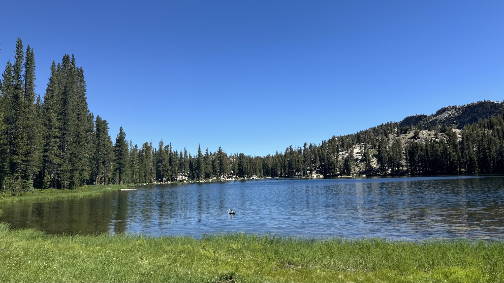
The largest Ten Lakes lake with grassy shoreline, forested far shore, and granite domes under a deep blue sky
The big lake — first stop for most backpackers.

The Main Lake

Big water, easy camps

The first major lake below the pass is the basin's social hub: a large, open lake with meadowy shores, established campsites in the trees, and plenty of room to swim. If you roll in late on a Saturday, expect company — then again, watching alpenglow from camp here is why you came.

Camp at least 100 feet back from the water in already-established sites, and remember the basin's evening breeze: a sheltered spot in the trees beats a scenic-but-exposed granite bench at 2 a.m.
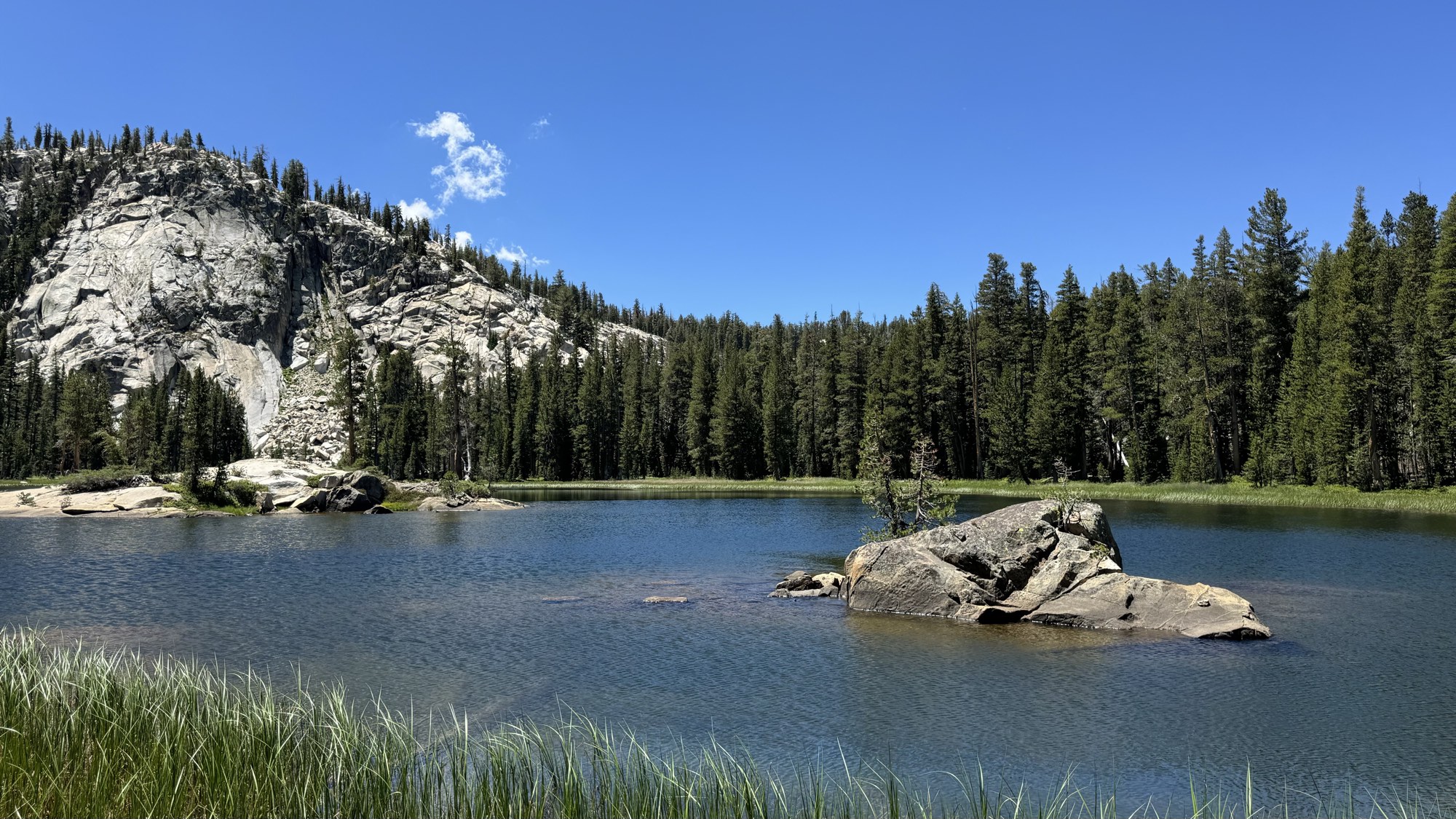
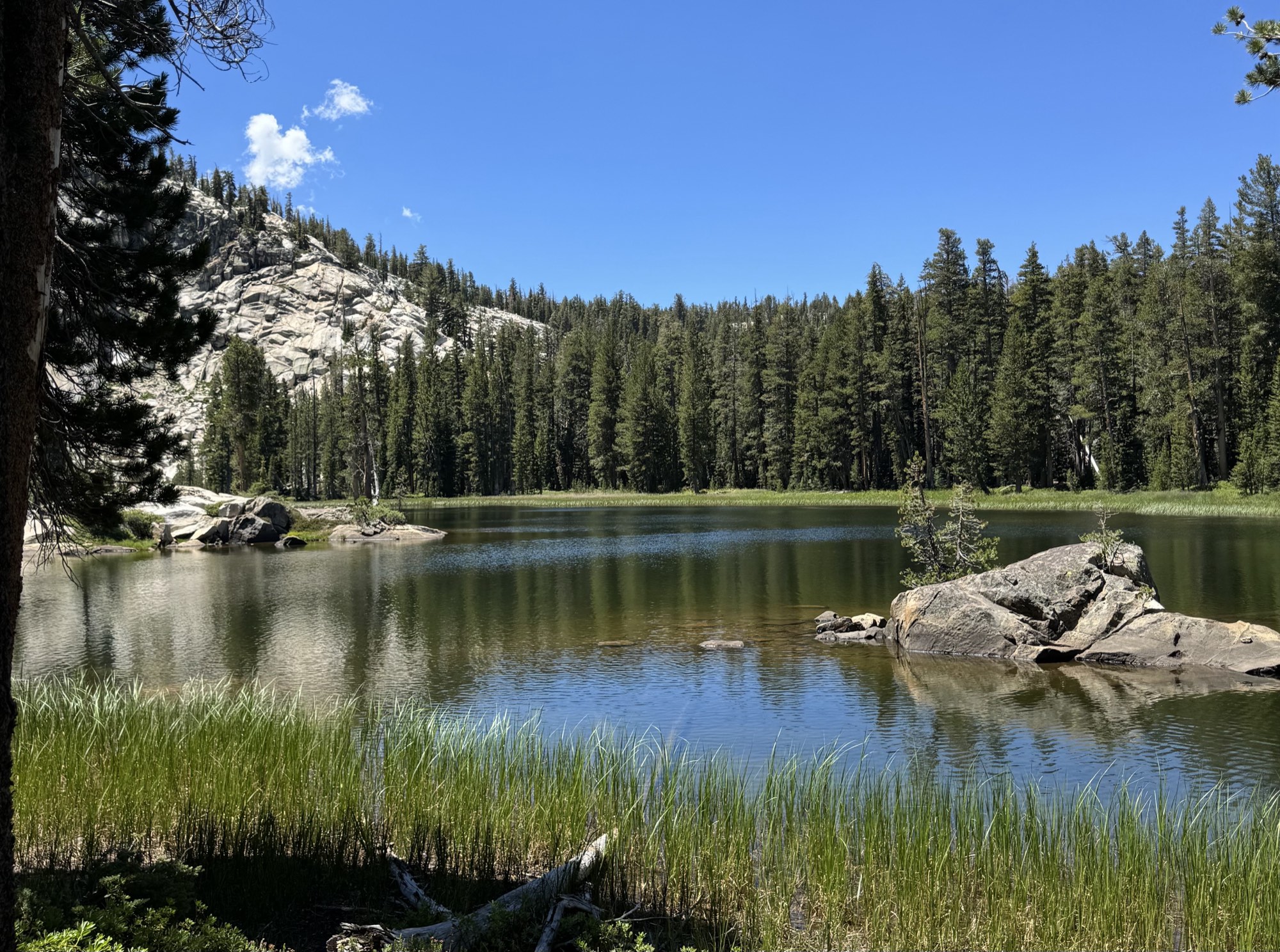
A Ten Lakes basin lake with a large boulder island, grassy shallows, and a white granite dome behind
Boulder islands and granite domes in the mid-basin.

The Middle Lakes

Where the crowds thin out

Push past the first lake and the basin changes character: lakes tucked between granite ribs, boulder islands, grassy shallows that glow green in July, and far fewer tents. The second lake — actually bigger than the first — is only a few hundred feet on, with ample flat camping between it and the third lake about half a mile northeast. The off-trail lakes are the lookers, ringed by slopes of nearly pure white granite.

These middle lakes are the sweet spot — close enough to reach with plenty of afternoon left, far enough that you might have one to yourself midweek.
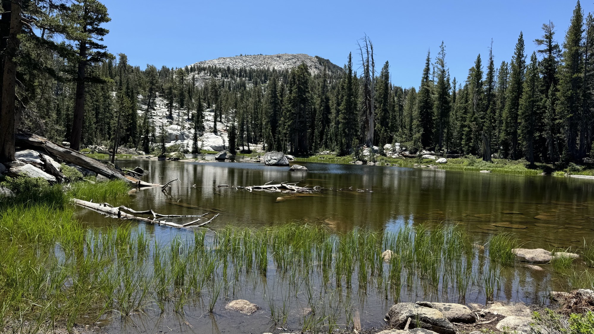
A shallow pond in the Ten Lakes basin with grass, driftwood logs and a granite dome behind
One of the basin's shallow ponds — part of how "ten" lakes got counted.

Ponds & Far Lakes

The quiet corners

Scattered between the named lakes are warm, shallow ponds — ankle-deep nurseries of grass and driftwood that explain how early visitors counted to ten. The farthest lake sits roughly 7.6 miles from the trailhead and sees a fraction of the traffic.

Wandering the benches between lakes is easy, open cross-country travel. If you leave the trail, keep your group small (park rules cap off-trail groups at 8) and step on granite, not meadow.

Lake (unofficial numbering)ElevationSizeNotes
First lake~8,990 ft~11 acresFirst reached from the pass; most campsites, most company
Second lake~8,950 ft~19 acresThe basin's low point, a few hundred feet on; good flat camping
Third lake~9,020 ft~6 acresHalf a mile northeast over a small ridge
Middle/upper lakes (2)~9,230–9,430 ft~10–11 acresQuieter shelves above the main cluster
East lake~9,400 ft~22 acresLargest in the basin; near the trail's climb east toward Tuolumne Peak
Northeast lake~9,010 ft~5 acresSmall, out toward the canyon rim
Grant Lakes (2)~9,260 / 9,460 ft~5 / 9 acresOver the divide via a 1-mile spur; white granite bowls, fewer people

Elevations and sizes are approximate, compiled from topo data; the numbering is conventional, not official.
Permits

Getting a wilderness permit

A wilderness permit is required for all overnight trips (day hikes need none). Permits are issued by daily trailhead quota — reserve under the "Ten Lakes" trailhead on Recreation.gov. Its quota (about 40 people per day) is friendlier than Yosemite's most famous trailheads, and midweek dates are very gettable.

24 weeks out: enter the lottery

The majority of each day's quota (currently 60%) is offered through a weekly lottery on Recreation.gov, opening 24 weeks (168 days) before your start date. Apply during the Sunday–Saturday window, get results Monday, and confirm by Thursday.

Missed it? Book leftovers or the 7-day release

Unclaimed lottery spots go on sale first-come, first-served after each lottery closes. The remaining 40% of the quota is released exactly 7 days before the start date at 7 am Pacific — a realistic shot for Ten Lakes, especially midweek.

Fees

Currently $10 per reservation plus $5 per person, paid on Recreation.gov. In the off-season (roughly November–April) permits are free via self-registration.

Pick up your permit in person

The trip leader picks up the physical permit the day before or the morning of the trip — most conveniently at the Big Oak Flat Information Station (Hwy 120 west entrance) or the Tuolumne Meadows Wilderness Center. Arriving after 11 am? Request a late arrival on Recreation.gov beforehand or the permit is released.

🐻Bear canisters are required

Yosemite requires an approved bear-resistant canister for all food, trash, and scented items everywhere in the wilderness — hanging food is illegal. Rentals are $5/week (plus deposit) at the wilderness centers, no reservation needed. Bear boxes at the trailhead hold whatever you're leaving in the car.

🔥Campfires: legal, with rules

The lakes sit below Yosemite's 9,600-foot fire line, so campfires are allowed in existing fire rings, 100+ feet from water, using dead-and-down wood — unless summer fire restrictions are in effect, which is common by late season. Check current conditions before you go.

Where you can camp

Camp in established sites at least 100 feet (about 40 paces) from water and trails. Groups max out at 15 on-trail, 8 off-trail. Permit holders can also spend the night before and after their trip in the backpackers' campgrounds ($8/person, no reservation).

🎫Park entrance

Yosemite's entrance fee is $35/vehicle (7 days), and the park is cashless. As of 2026 no peak-hours vehicle reservation is required — but this policy has changed year to year, so verify on nps.gov before your trip.

Parking & Directions

Finding the trailhead

The Ten Lakes Trailhead is on Tioga Road (Highway 120) right where it crosses Yosemite Creek — about 20 miles east of Crane Flat, 5 miles east of the White Wolf turnoff, and 25 miles west of Tioga Pass. GPS: roughly 37.852, −119.577.

🅿️Two lots, one corner

  • North side (Ten Lakes side): unpaved lot with bear boxes and trash cans — the trail starts here.
  • South side (Yosemite Creek trailhead): paved lot with vault toilets and bear boxes, directly across the road.
  • Together they hold only around 30 cars; overflow parking is at the Yosemite Creek picnic area just down the road.
  • No potable water at the trailhead — arrive with bottles full.

🚗Good to know

  • Summer weekend mornings, arrive early for a spot in the main lots.
  • Overnight parking is allowed with a wilderness permit, but ends October 15 along Tioga Road each year.
  • Leave zero scented items in your car — use the trailhead bear boxes.
  • Coming from Yosemite Valley, allow about an hour of driving.
Driving fromDistance to trailheadRoute
Big Oak Flat Entrance (Hwy 120 W)~28 milesHwy 120 east past Crane Flat, onto Tioga Road
Crane Flat~20 milesTioga Road east; trailhead at the Yosemite Creek crossing
Yosemite Valley~35 miles (≈1 hr)Big Oak Flat Rd to Crane Flat, then Tioga Road east
Tuolumne Meadows~18 milesTioga Road west
Tioga Pass Entrance (Hwy 120 E)~25 milesTioga Road west, past Tenaya Lake

Open the trailhead in Google Maps →

When to Go

Season & timing

The trailhead is only reachable while Tioga Road is open — typically late May or June through late October or early November, entirely dependent on snowpack. The road has opened as early as mid-May (2026) and as late as July 22 (2023's record snow year).

🌼Early season (June–mid July)

Big water, big wildflowers, big mosquitoes. Expect lingering snow on the pass and the north-facing descent, and fast, cold creek crossings. Bring a head net and repellent — the bugs near the lakes can be fierce until things dry out.

☀️Prime time (late July–September)

Snow-free trail, swimmable (if brisk) lakes, and fading mosquitoes — this is the window most trips should target. Watch for afternoon thunderstorms: plan to be over the pass and off open granite by noon.

🍂Fall (late September–road closure)

Cold nights, zero bugs, empty campsites, and golden meadows. Days are short and early-season storms can arrive with little warning — check the forecast and remember overnight trailhead parking ends October 15.

Check before you drive: Tioga Road status changes with the first real storm. The park posts current road and trail conditions at nps.gov/yose, and Tioga opening/closing dates vary by weeks from year to year.

Trail Wisdom

Tips for a better trip

💧Water strategy

There's no water at the trailhead, and the switchbacks and pass are the driest stretch. Fill up at Half Moon Meadow, and treat everything — giardia is present in Sierra water. Filter, purifier, or boiling all work.

⛰️Respect the altitude

The basin sits near 9,000 feet and the pass higher. If you're coming from sea level, a night at altitude beforehand (the backpackers' campgrounds work well) makes the climb dramatically more pleasant.

⛈️Beat the storms

Summer thunderstorms build over the high country most afternoons. Start early, be over Ten Lakes Pass before noon, and stay off open granite and away from lone trees when cells move through.

📵No cell service

Expect zero reception from trailhead to basin. Download offline maps, carry a paper map, and consider a satellite messenger. Tell someone your itinerary and exit date.

🧭Don't lose the trail

The granite slab section around mile 1 swallows the tread. Follow cairns and worn rock, and glance backward occasionally so the route looks familiar on the return.

🎣Pack the rod

The basin fishes well for small, eager brook trout — descendants of stocking that ended in 1991 — though a few lakes are fishless. Anglers 16+ need a California license, and live or scented bait is prohibited everywhere in the park.

FAQ

Common questions

Are there really ten lakes?

Depends on how you count. The basin holds about seven significant lakes plus a scattering of ponds and tarns, and the two Grant Lakes sit just over the ridge. The "ten" comes from John Muir, who described "ten lovely lakelets lying near together in one general hollow, like eggs in a nest" — count his lakelets, or fold in the Grant Lakes, and the math works.

Can I do Ten Lakes as a day hike?

Yes — it's a strenuous but popular 12.5–13 mile day at 7–9 hours for most hikers, and day hikes need no permit. That said, the basin rewards a night: sunset and sunrise on the water are the best parts.

How hard is it to get a permit?

Easier than most Yosemite classics. The Ten Lakes trailhead quota is around 40 people per day, and midweek dates often remain available in the 7-day release. Weekends in August are the tightest.

Which lake should I camp at?

The first (largest) lake has the most established sites and the easiest access — ideal for a first trip or a late start. For quiet, continue to the middle and far lakes; even half a mile deeper into the basin thins the crowd dramatically.

Is there water along the trail?

Plenty in the first four miles (Yosemite Creek tributaries and Half Moon Meadow) and everywhere in the basin, but almost none on the switchbacks and pass. None at the trailhead. Treat all of it.

Can I bring my dog?

No. Pets aren't allowed on Yosemite wilderness trails, including the whole Ten Lakes route.

Are campfires allowed?

Yes, in existing fire rings — the lakes sit below the park's 9,600-foot fire line. But summer fire restrictions frequently ban fires park-wide by late season, so check current conditions before counting on one.

What about bears (and marmots)?

Black bears roam the whole park, and an approved bear canister is legally required for overnight trips (rentals at the wilderness centers). Keep it 100 feet from your tent, and stash car food in the trailhead bear boxes. The basin's boldest thieves are actually marmots — trip reports regularly mention them strolling into camp, so keep anything scented in the canister even at lunch.

Can I fish the lakes?

Yes — the basin holds self-sustaining brook trout (some lakes are fishless), and the fishing can be fast. You'll need a California fishing license if you're 16 or older; live and scented bait are banned park-wide, and the general limit is 5 trout per day. Check NPS fishing rules for specifics.